|
An FX Celebrity & An Old Paper
Mill…Is There A Connection?
by
Ryan Biziorek, January 17, 2002, Kalamazoo College - Urban
Economics

When you drive by a neighborhood and see an
empty parcel of land, a bit of curiosity may make you wonder,
“Why is that piece of land empty?” Often in cities today, there
are not many empty parcels of land unless they are parks,
contaminated areas, or new housing developments with parcels
just waiting to be sold. Here in Kalamazoo there is an empty
parcel of land in the east side neighborhood. The land is on
the corner of Lake and Clarence and looks to be around 120ft. x
120ft. Why is it empty? Who owns it? What was it used for in
the past? How is it zoned? These are some of the questions
that we will hopefully answer about this mysterious open area.
On a sunny Sunday afternoon, a short drive
out to Lake and Clarence proved to make the mystery larger then
thought to be. This was the first time my partner, Jill, and I
have seen this empty lot and it was spooky. There were many
homes right next to it and businesses down the street on Lake,
but this lot was empty. The first goal in mind was to find some
clues about the address. Some sort of utilities box (most
likely a telephone routing box since Ameritech had a sticker on
it) was labeled with 1011. This seemed a very likeable address
since the adjacent homes had similar address values.
In addition to the utility box, there were
some other clues around that may tell us who owned this empty
lot. The first clue was a “Bus Stop” sign on the corner of the
lot. Does the city own the land? Another clue was the nearest
business on the north side of Lake Street. The business was
Pipeline Maintenance Services Inc. (PMSI). Sure, this may not
seem like a significant piece of information, but this was a
storage area for their trucks and there were only two trucks
inside the fenced area. Does PMSI own the empty piece of land
and never expanded their fenced area? Just looking at the
parcel does not provide the answer to this question, so we were
off to the public library.
At the library, we hoped to use a plat map
to figure out who owned the land. Unfortunately, the map did
not have enough detailed information to show who owned the
land. Browsing through some of the other maps, we came across
an old insurance map. This book showed each building within the
city and its structure type for building insurance purposes. On
the corner of Lake and Clarence in the 1930’s there were homes
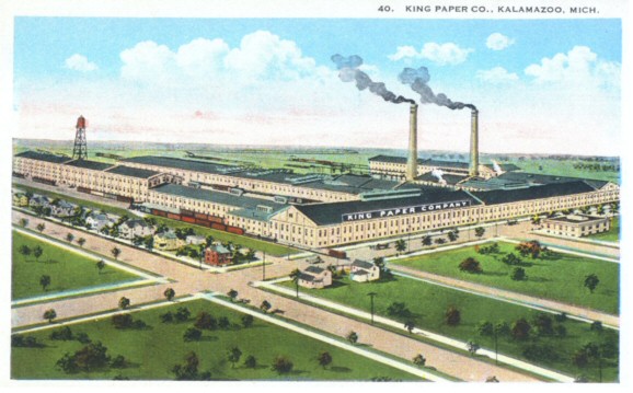
right next to a paper mill named King Paper Company. Many
questions quickly came to mind. Did the paper mill own this
land in order to house their workers? What happened to the
paper mill? Was it torn down? Did it declare bankruptcy? Some
more answers were needed so a trip to the City Assessor’s Office
was our next step.
If you ever need to find information on a
piece of land, the City Assessor’s Office is an amazing
resource. With an address, a simple computer search can be
performed to find out the real estate information of the land.
Detailed maps of city land are also available. With the help of
an employee, Frankie, I searched for 1011 Clarence Street. I
discovered a lot of information and many of our basic questions
were answered. The lot is owned by Arthur P. Dore from Bay
City, Michigan. It is zoned as a class seven area, a multiple
family residence district. Apartments, fraternities, and even
rest homes can be built on zone seven lands. Valued at
$4,091.00 and a size of .14 acres, the lot was completely
empty. After my excitement subdued, I noticed on the real
estate summary sheet that the lot only covered 45 ft. of
Clarence Street. This was not the whole corner of Lake and
Clarence. Who owned the other portion of land?
Another trip to the City Assessor’s Office
by Jill unearthed that the property on Lake and Clarence did
have other parcels on it. In addition to this, she discovered
that Arthur Dore also owns these parcels and some land next to
it on Lake Street. After mentioning the old paper mill that
used to be in the area, Frankie told Jill that she had heard
that land was contaminated. After discussing our information,
we made another trip down to the City Assessor’s Office. Using
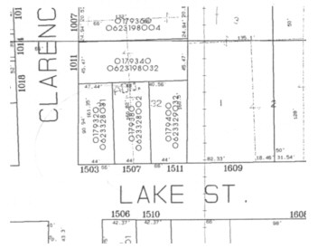
the computer search again, we found that Arthur Dore owns 1011
Clarence, 1503, 1507, and 1511 Lake Street. These areas are all
zone seven lands and total to a value of $12,531 and acreage of
.42 acres. In addition to this residential land, Mr. Dore also
owns a large piece of zone one land (general manufacturing
district) with an address of 1609 Lake Street and some other
small pieces of zone seven lands on East Vine Street. Mr.
Dore’s real estate totals up to over 10 acres and a value over
$100,000. Still, we wanted to know more. Was it for sale?
Were there plans to build on the land? A few phone calls
answered some of these questions.

I first called Rita Corsi at the Planning
Office, who was a very helpful resource. She was able to tell
me many of the same pieces of information that I had found
before, but the biggest help was that Dore Enterprises owned the
land. Recently, she has had many inquiries on the land but has
not seen a site plan packet to review so there were not any
plans to build on it at the moment. Using the business name, I
was able to find their phone number and location on the
Internet. Sure enough, Dore Enterprises was located in Bay
City, Michigan. When I called, I inquired about the property
and a woman by the name of Sheri Fisher spoke with me. She
explained to me that Mr. Dore owned a wrecking company and they
were hired to tear down the paper mill that used to be there.
In return for tearing down the mill, Mr. Dore received some of
the land as a payment. He has had the property for over 20
years. When I asked if it was for sale, she replied,
“Everything is for sale.” After I laughed, I confirmed that if
the offer price was high enough, then the land could be mine.
After all this research, the paper mill was
still in the picture. To find out more about this mill, we took
another trip to the public library. With the help of a
librarian, we found many different articles about the King Paper
Company in the Kalamazoo Gazette. A photo with a large caption
from January 5, 1978 informed us that the Dore Wrecking Company
was hired to demolish the site but delayed to do so. In March
1976, the city sued Dore for his delays and was given 180 days
to finish the demolition as a result. Eventually, Dore was
found in contempt of the court in July 1978 and was given until
November 15, 1978 to have the job finished without a penalty.
After this deadline passed, Dore was fined $50 a day until the
job was finished. His fine totaled $1,250 when the site was
cleaned to the judge’s satisfaction, but there were still some
other small things to be done and the judge gave Dore another 30
days to finish.
After finishing our research at the
library, we decided to stop by the City Planner to see if we
could find out any information on the future use of this land
and if Frankie was right about the contamination rumors. We
were referred to the Development Manager, Chad Howell, who was
very happy to speak with us after he found out that we were in
Dr. McKinney’s class. He had a large file on this land and knew
all of the history behind it. It turns out that Mr. Dore is the
owner of not only a wrecking company, but also owns and hosts
the Toughman show on FX! He explained to us that the paper
company that used to be there ended up going out of business.
After many years, the building became old and the city ordered
that it be torn down. At one time, the city was interested in
acquiring the land at 1609 Lake Street but Mr. Dore wanted more
money then the city thought the land was worth. The land isn’t
worth that much either because the foundation of the paper mill
was never torn out and there is some ground contamination.
Although the industrial land may be contaminated, Mr. Howell
assured us that the residential land at the corner of Lake and
Clarence is not contaminated.
We asked him why there was land zoned for
residential use right next to land zoned for industrial use.
Mr. Howell told us that this was something that hasn’t been
changed over time but it is inappropriate. To correct this, the
zone one land would be changed to zone two, a light
manufacturing district. Sure enough, a look at the city’s
future planning map showed 1609 Lake Street to be rezoned as
zone two.
That small vacant corner had more history
behind it then I had ever imagined. The next time I research a
vacant piece of land within a city, I will certainly go straight
to the Planning Board first. I believe that these vacant areas
are of a high interest to the city in case they want to purchase
them for some type of future developments or promote business
growth. The City Assessor’s Office would be the next place to
go because you can get a great deal of information with just an
address. Next time, I will certainly target the majority of my
research efforts in these two places.
WORKS CITED
Corsi, Rita. Kalamazoo Planning Office.
Personal & Phone Interview. 16 January 2002.
Frankie. Kalamazoo City Assessor’s
Office. Personal Interview. 14 & 16 January 2002.
Fisher, Sheri. Dore Enterprises. Phone
Interview. 16 January 2002.
Howell, Chad. Kalamazoo Planning Office.
Personal Interview. 16 January 2002.
Insurance Maps of Kalamazoo, Michigan.
Map. 1931 ed. Broadway, NY: Sanborn Map
Co., 1908.
Return to the
Links Page
|